What is the Reimaanlok Framework?
The 8-step Reimaanlok Conservation Area Management Planning Framework helps atoll communities in the Marshall Islands think globally and act locally. It employs community-based tools and approaches to articulate local objectives that translate to national, regional and international goals.
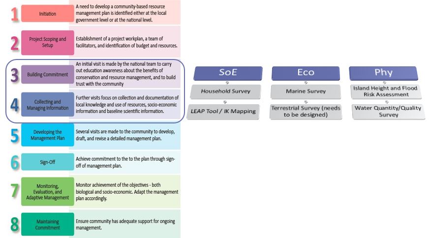
Reimaanlok Process Diagram
Specifically, the Reimaanlok eight step process, when triggered by an atoll community’s leadership (Step 1), includes a scoping and budgeting exercise (Step 2), site visits by Reimaanlok facilitators to build awareness on the need for resource planning by the target atoll community (Step 3), followed by the gathering and analysis of various natural and social resource data parameters (Step 4) in order to design (Step 5) and ultimately legislate (Step 6) an integrated atoll resource management plan inclusive of programs to ensure ongoing monitoring and adaptive management (Step 7) and local commitment retention (Step 8). Given the specific needs and unique circumstances of atoll municipalities, the Reimaanlok facilitation consortium known as the Coastal Management Advisory Council (CMAC) may follow these eight steps in a linear or iterative process. This helps foster a sense of trust and shared purpose within the community and of the Reimaanlok facilitators, so that the process itself is an empowering experience for atoll communities and a vehicle for national cohesion and shared purpose among members of CMAC.
Among the many noteworthy atoll-appropriate features of the Reimaanlok process, in Step 3 a Local Resource Committee (LRC) is established by the municipal government which then oversees the development of the resource management plan in that atoll. Step 4 is also noteworthy in that it entails gathering rich datasets along socioeconomic, ecological, and physical parameters. These data inputs feed into the ConservationGIS database being developed by CMAC.
Some communities using this approach are finding early success as they proceed in the step-by-step process of articulating threats and their needs and priorities, codifying these into a management plan with various short, medium, and long term measures including in enhancing their ecosystem and socio-economic resilience to climate impacts. Moreover, these municipalities/communities remain engaged in the process of implementing and monitoring these measures as a unifying endeavor for their community.
At the national level, the Reimaanlok Framework is finding success as well, as it becomes increasingly mainstreamed within national government legislation, governance, and financing systems most importantly within the RMI Protected Area Network (PAN). In addition to smaller grants from funding partners such as GEF Small Grants Program, the Nature Conservancy and the Micronesia Conservation Trust, there are a few large funding initiatives that advance the Reimaanlok Framework (national and regional) including:
United Nations GEF-5 Ridge to Reef Project
International Union for Conservation of Nature
Asian Development Bank - Ireland Trust Fund
World Bank
Global Environment Fund


